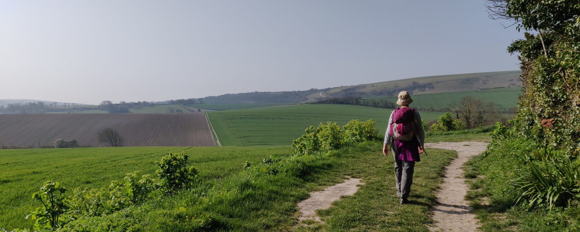
Before I went to Nepal I had booked this trip to have a walking holiday with friends in Southern Spain. The friends in question are from an informal walking group, Clare of Nepal fame, Chris (retired teacher), Margaret (Accountant, our children grew up together) and me. So just in case you missed it we are no spring chickens, ranging between 55 years and 69 years old!
We are staying in Nerja, on the south coast about 40 minutes east of Malaga. We spent a few days relaxing and acclimatising to the warmth and sun, (for this read swimming in th sea/pool and laying on the beach).
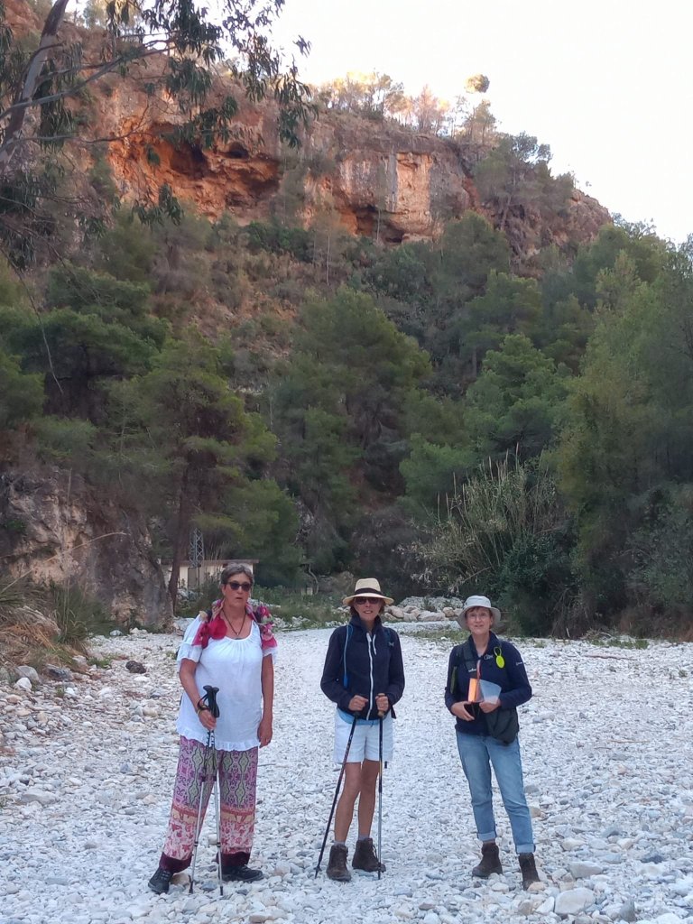
Our first walk was to be a loop taking in the Rio (river) Chillar, which means scream in Spanish! Perhaps I should have taken this as a warning as the walk was not what it said in my book.
This was meant to be a relatively easy walk. We are experience walkers and in the book it was described as being a level 3; with 1, being a doddle where your granny (they obviously don’t know my friends) and a pushchair can do it; to 10, needing specialist climbing gear.
I read a couple of reviews about the walk which is 13km walk, and the time varied between 3.5 hour to six hours walking, I felt we would probably be in the latter category. It also said there were some precipitous and narrow sections. This looked like a good first walk for us.
The Chillar runs from the Sierras of Tejeda, Almijara and Alhama Natural Park a mountainous region through various gorges and into the Mediterranean west of the town of Nerja.
We set off at 0835 hours. The start of the walk for us was from an urban area where we parked the car. We walked down a road, under the dual carriageway and into the ravine.

The river bed was dry at the begining due to it being diverted to supply the town. It was pleseant and easy going. The sun was shining and we had started early enough to avoid the heat of the afternoon. The track was wide and cliff on both sides hinting at what was to come.
We had only walked about a couple of kilometres when we needed to turn off and climb up to a water channel as instructed by the book. From here on in we discovered the book lacked a lot of detail.
It said the climb was steep, and it was. It was also scree in places, very long and quite challenging for all. Chris has a problematic knee but she got her stride, Margaret and Clare were on their knees at points but we went up slowly.
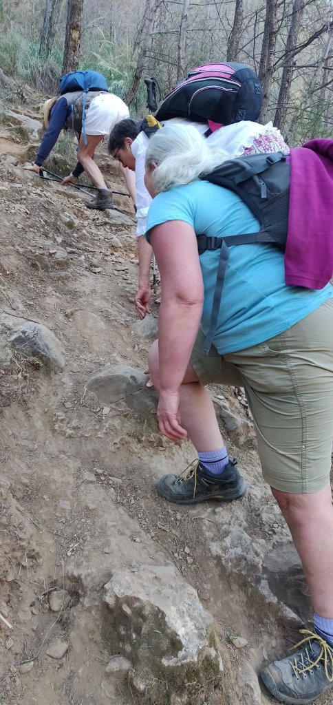
We had been climbing for some time and not seen the water pipe or the channel we were supposed to be following and I began to think we had made a mistake. Then I started to worry because getting down would be a great deal harder than going up. We stopped and all I can say is thank goodness for my maps (in particular my mum’s old map), and rather weirdly the ordinance survey app.
But the ordinance survey app does not work outside the UK I here you say! Ah but, the mapping does as long as you have data! It gives contours and some landmarks and trails. While we sat drinking water and eating boiled eggs, Margaret managed to get her Ordinance Survey App partially loaded and I saw a glimmer of hope.The map in the book and my map did not show the water course at all so I had no idea if we still needed to climb or if we had missed it. Then the Ordinance survey map suddenly loaded on my phone and as I zoomed in I saw a faint line of blue at 400 meters above sea level, we had another 200 meters up to go, I didn’t tell the ladies that bit!. Slow and steady we climbed up and up. It was now quite hot and we had veiws of Nerja and the sea in the distance.
Finally we found the water course.
By now we had been walking up nearly 3 and a half hours!
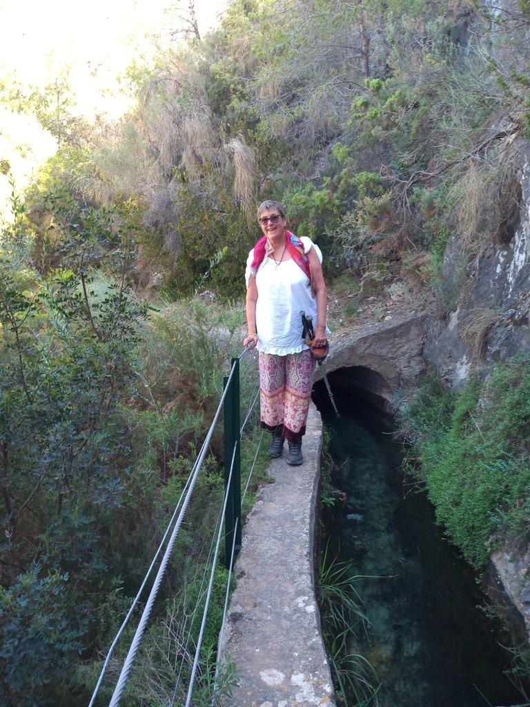
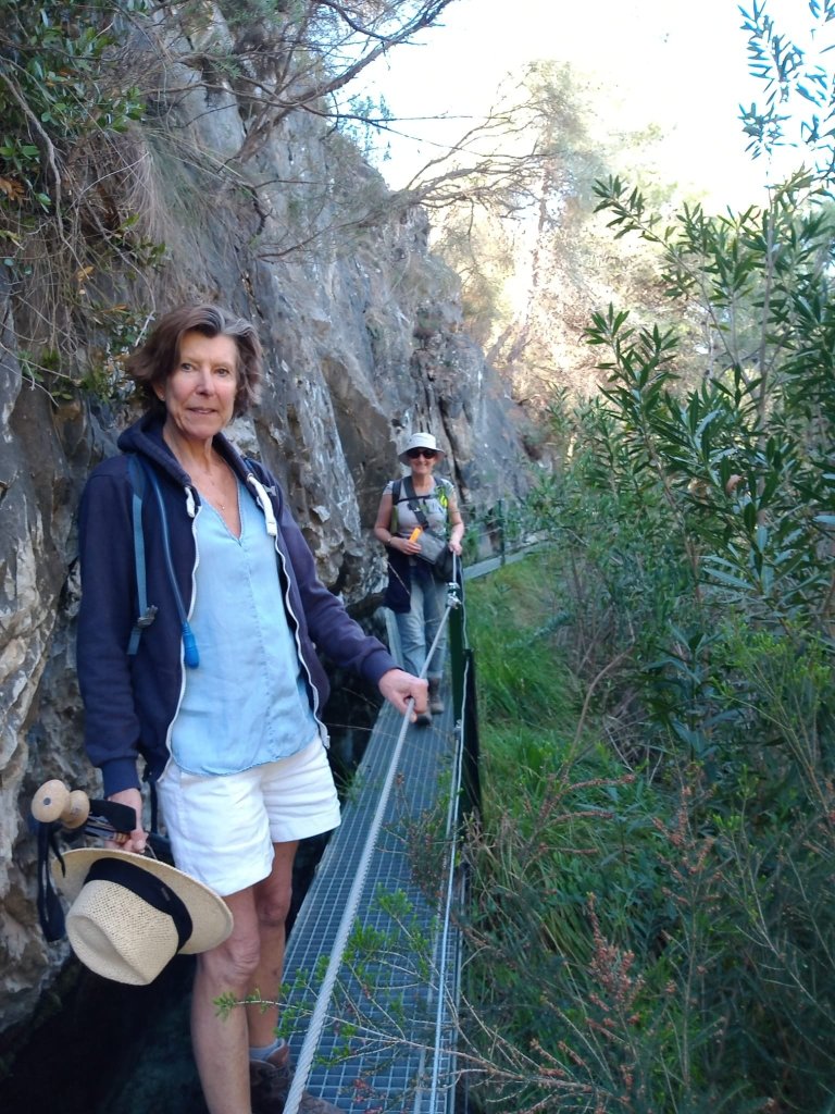
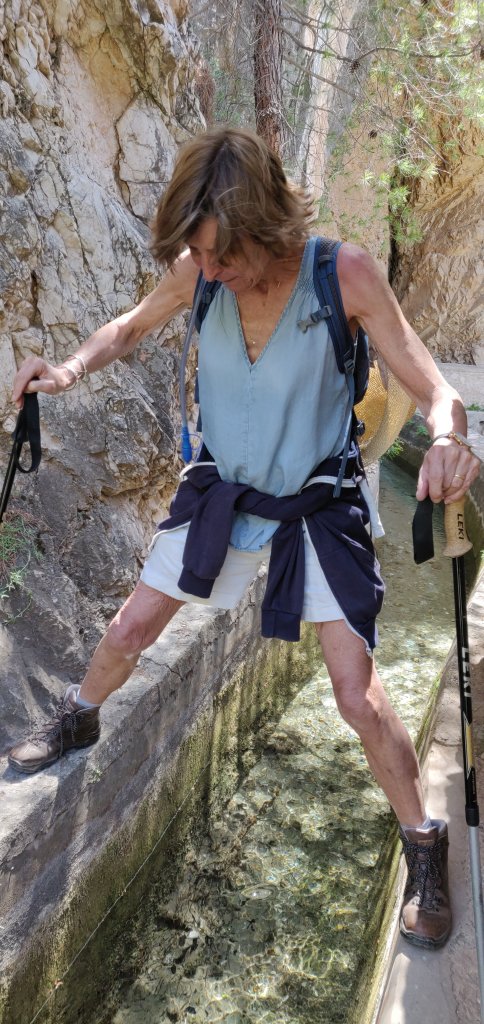
The watercourse is a narrow cement channel with a very narrow cement edge that we were going to be walking along. It looked fine, there was a wire rail on the down side which was a sheer drop and on the other the water was only about 3 feet deep and very clear. This would take us along high above the ravine and it was level.
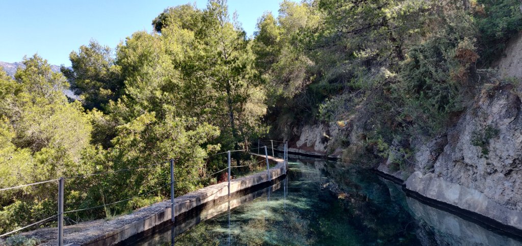
Again this water supplies Nerja, and the water is so clear it’s almost blue with the limestone minerals. There were beautiful plants growing in it, the odd eel and pond skaters.
Feeling good we set off.
First the rail disappeared! Then cement edge which was about a foot wide, in places was uneven and crumbling. It became a nightmare!
Chris’s and Clare’s balance is not great. Margaret was OK and I’m pretty sure footed. As Chris was the wobbliest I gave her a stabilising hand when she needed it, much of the time she walked carefully with her arms out to the sides. Clare is fine if its level, which it was but, she had a couple of wobbly moments and nearly did the splits at one point with a leg either side of the channel, thank god she didn’t tip the other way. Some parts the channel were covered over with crumbling cement so we had to be extra careful getting on and off these and Chris very nearly fell, hung off a cement lump, gripping the with hands and the inside of her knees like a climber, grazing her leg on the rough surface as she got herself back onto the ledge.

The only times we really got to look at the veiws were when we stopped for a break or a short stretch hand rail appeard. The veiws were fantastic and it was very peaceful but the tension in the group was palpable. Chris’s body was starting to hurt with it.


If there had been anyway down that was not as steep as the way up, I would have taken it but, there were no other paths down at all. Then I was worried about what the down path was going to be like when we got there.
I want to say we only took photos when it was safe to do so and maybe the pictures don’t always show what a sheer drop it was.

This section of our walk took nearly 4 and a half hours! Weirdly the others didn’t seem to realise how long we had been walking.
How old was the bloody man who wrote the guide book? Did he run it? All the time I’m thinking what happens if one of us fall off?
Finally we made it to the Cueva de la Palomas (The cave of Doves) which then saw Clare and Chris both attempt the splits to get around a big rock without falling in the water. Margaret managed with a pole and I hopped across. But this meant we were near the track going down to the river phew!
Finally we found the track down and we rested before the descent.
Next the ravine…..

Hi Debs & Friends, glad you are all enjoying the challenges of the days!! I have to admit my tummy felt a bit wobbly when looking at some of the drops but know you are all in good hands and as Clare has her go to walking sticks I am sure they’ll be as good as in Nepal as long as she doesn’t accidentally whack you with them! Loved the short video and loving the scenery …ps glas you decided to do a bold and see how much up to date travel blogs are needed in detail for others! Get printing Debs! Xxx💕
LikeLike
Bloody hell daughter, I’m not going walking with you again.
Dad
LikeLiked by 1 person
Chris says, neither are Chris, Clare and Margaret. Mwhahaha I know different 🤣
LikeLike
Clare says the above is a 🤥
LikeLike
Don’t blame you Dad! Reading the adventures from the sofa spring to mind!
Linda Debs friend who spoke to you on Face Time 🤗x
Ps Sorry for the typo’s Debbie but I am sure you worked it out!😂
LikeLike